















































Indonesia Earthquake: 7.7 Quake Triggers Tsunami Warning
Indonesia earthquake: A magnitude 7.7 quake struck near Flores, triggering tsunami warnings as officials reported waves and assessed damage.
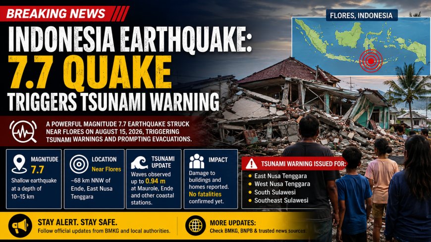
Indonesia earthquake activity surged into international headlines on Saturday, August 15, after a powerful magnitude 7.7 earthquake struck near Flores and prompted Indonesia’s authorities to issue tsunami warnings for several coastal regions. The U.S. Geological Survey placed the earthquake about 68 kilometers north-northwest of Ende in East Nusa Tenggara, while Indonesia’s Meteorology, Climatology and Geophysics Agency, known as BMKG, located the event about 30 kilometers northeast of Mbay in Nagekeo and initially gave it a depth of 15 kilometers.
The most important development is that the tsunami threat moved beyond a warning based only on computer modeling: BMKG later reported measured tsunami waves at several monitoring locations. The agency recorded a wave of about 0.94 meters at Maurole in Ende, while smaller waves were detected at other coastal sites, including Flores Timur, Labuan Bajo, Sikka and Pelabuhan Kewapante.
That does not mean a destructive regional tsunami swept across Indonesia. Instead, the observations show why authorities treated the shallow earthquake as a serious coastal hazard and ordered people in vulnerable areas to move away from beaches and other low-lying locations.
What happened in the Indonesia earthquake?
The earthquake struck offshore in eastern Indonesia near the Flores region during the early hours of Saturday local time. BMKG’s event record lists the magnitude as 7.7, with the epicenter approximately 30 kilometers northeast of Mbay in Nagekeo, East Nusa Tenggara, at a depth of 15 kilometers. The USGS independently reported a magnitude of 7.7 and placed the epicenter 68 kilometers north-northwest of Ende at a depth of about 10 kilometers. Differences of several kilometers in preliminary earthquake locations are common because agencies use different seismic networks and processing methods.
The quake was strong enough to be widely felt across Flores and surrounding areas. Reports cited by the Associated Press said people rushed from homes as the shaking continued, while local authorities began assessing damage. Initial reports included damage to buildings and homes, with a waiting-room structure at the Pelni port terminal in Maumere reported to have collapsed. No deaths had been immediately confirmed in the early reports available as authorities continued their assessments.
The earthquake was followed by several aftershocks, adding to concerns for residents already evacuated from coastal areas. Early reports cited aftershocks in the magnitude 5 range and above, making continued monitoring important even after the strongest initial shaking had ended.
Why did Indonesia issue a tsunami warning?
BMKG issued an early tsunami warning because the earthquake was powerful, shallow and located close enough to coastal communities for significant sea-level disturbance to be possible. Tsunami warnings are not declarations that a large destructive wave has already arrived; they are precautionary instructions issued when an earthquake has characteristics capable of generating dangerous waves. In this case, authorities warned people in parts of East Nusa Tenggara, West Nusa Tenggara, South Sulawesi and Southeast Sulawesi to stay away from coastal areas and move toward safer, higher ground.
Subsequent observations provided important real-world information. BMKG reported tsunami measurements of 0.14 meters at Bakalang-Alor, 0.30 meters at Baubau, 0.54 meters at Bulukumba, 0.17 meters at Dompu, 0.25 meters at Flores Timur, 0.36 meters at Labuan Bajo, 0.94 meters at Maurole in Ende, 0.38 meters at Pelabuhan Kewapante-Sikka and 0.19 meters at Sikka.
The measurements show that tsunami effects were detected at multiple monitoring points, but they do not by themselves establish that every warned coastline experienced dangerous flooding. The size and impact of a tsunami can vary sharply from one coastal location to another because of seafloor shape, shoreline geometry, distance from the source and local bathymetry. That is why residents were told to follow official instructions rather than judge the danger from conditions at one particular beach.
Where was the earthquake centered?
The earthquake occurred in the Flores region of eastern Indonesia, close to East Nusa Tenggara. BMKG’s preliminary coordinates were 8.41 degrees south and 121.39 degrees east, placing the source near Mbay in Nagekeo. The USGS location was somewhat different, putting the epicenter 68 kilometers north-northwest of Ende. Both agencies place the event in the same broader offshore Flores area.
That location matters because Flores and the surrounding islands sit within one of the world’s most seismically active regions. Indonesia lies along the Pacific Ring of Fire, where several tectonic plates interact and earthquakes and volcanic activity are frequent. The area around Flores has experienced damaging earthquakes and tsunamis in the past, which helps explain why authorities reacted quickly to the latest event.
Indonesia’s earthquake risk is not limited to one fault or one island. The country stretches across a complex network of active tectonic boundaries, so a major earthquake can quickly become a wider emergency when coastal communities, ports and transportation routes are involved.
What damage and casualties have been reported?
Early damage reports remain subject to change because emergency teams were still surveying affected communities. The Associated Press reported damage to buildings and homes and said a Pelni port terminal waiting room in Maumere collapsed. At the time of those reports, authorities had not confirmed fatalities from the earthquake.
The USGS PAGER system also provides a useful distinction between confirmed casualties and modeled risk. Its automated assessment indicated that localized casualties and structural damage were possible based on the earthquake’s magnitude, depth and population exposure. Such estimates are hazard assessments, not official counts of people killed or injured, and they should not be presented as confirmed casualty figures.
This distinction is especially important during the first hours after a major earthquake. Communications can be disrupted, roads can become difficult to access and local authorities may need time to inspect buildings before reporting reliable numbers. As a result, early casualty and damage figures can change as field assessments become available.
What happens next after the quake?
Authorities are expected to continue monitoring aftershocks, coastal water levels and reports of structural damage. After a major earthquake, officials also need to determine whether damaged buildings remain safe to occupy and whether roads, bridges, ports and other critical infrastructure have been affected.
For coastal residents, the most important instruction remains to follow BMKG and local emergency authorities rather than rely on social-media reports. The initial warning and subsequent measurements demonstrate that even a relatively modest observed wave can accompany a major offshore earthquake, while local conditions can make impacts different from one shoreline to the next.
The latest confirmed information shows that tsunami waves were detected at several Indonesian monitoring stations after the magnitude 7.7 event. The full scale of structural damage and any possible casualties was still being assessed in the early reporting period, so claims circulating online that go beyond confirmed official or emergency-service information should be treated cautiously.
Why the Flores region is vulnerable to earthquakes and tsunamis
The Flores region’s exposure is linked to Indonesia’s broader tectonic setting. The country sits across several active plate boundaries, creating conditions for frequent earthquakes, including shallow offshore earthquakes capable of disturbing the sea floor.
Historical experience also shapes the response. Indonesia has suffered some of the world’s most destructive earthquake-generated tsunamis, including major disasters in the broader eastern Indonesian region. BMKG maintains a historical tsunami catalog covering centuries of events, demonstrating that tsunami generation is a recurring hazard rather than an unusual possibility for Indonesia’s coastal communities.
The current event therefore matters beyond the immediate shaking. The measured waves provide authorities with additional data about how this particular earthquake affected the sea, while continued aftershock monitoring will help determine whether further hazards develop.
Indonesia earthquake: Frequently asked questions
How strong was the Indonesia earthquake?
The earthquake was measured at magnitude 7.7 by BMKG and the USGS. The agencies differed somewhat on the precise epicenter and depth, but both placed the event in the Flores region of eastern Indonesia.
Did the earthquake cause a tsunami?
Yes. BMKG reported measurable tsunami waves at multiple monitoring locations, including a maximum reported measurement of about 0.94 meters at Maurole in Ende. The measurements varied significantly between locations.
Where did the earthquake hit in Indonesia?
The earthquake occurred near the northern side of Flores in East Nusa Tenggara. BMKG placed it about 30 kilometers northeast of Mbay in Nagekeo, while the USGS placed it 68 kilometers north-northwest of Ende.
Were people killed in the earthquake?
No fatalities had been immediately confirmed in the early reports reviewed for this article. Damage to buildings and homes was reported, including the collapse of a waiting-room structure at the Pelni port terminal in Maumere, but casualty assessments were still developing.
Which areas received tsunami warnings?
BMKG issued tsunami warnings covering parts of East Nusa Tenggara, West Nusa Tenggara, South Sulawesi and Southeast Sulawesi. Residents in vulnerable coastal locations were advised to move away from the shore and toward safer ground.
Could there be more earthquakes after the main quake?
Yes. Several aftershocks were reported following the magnitude 7.7 earthquake. After a major earthquake, additional seismic activity is possible, which is why authorities continue monitoring the region and assessing infrastructure.
What's Your Reaction?
 Like
0
 Dislike
0
 Love
0
 Funny
0
 Angry
0
 Sad
0
 Wow
0