



















































Hawk Fire Reno Update: Evacuations, Maps and Power Outages
The Hawk Fire near Reno has forced thousands to evacuate as winds drive the blaze. Read the latest on evacuation zones, roads, power and shelters today.
Hawk Fire Reno Update: Evacuations, Maps and Power Outages
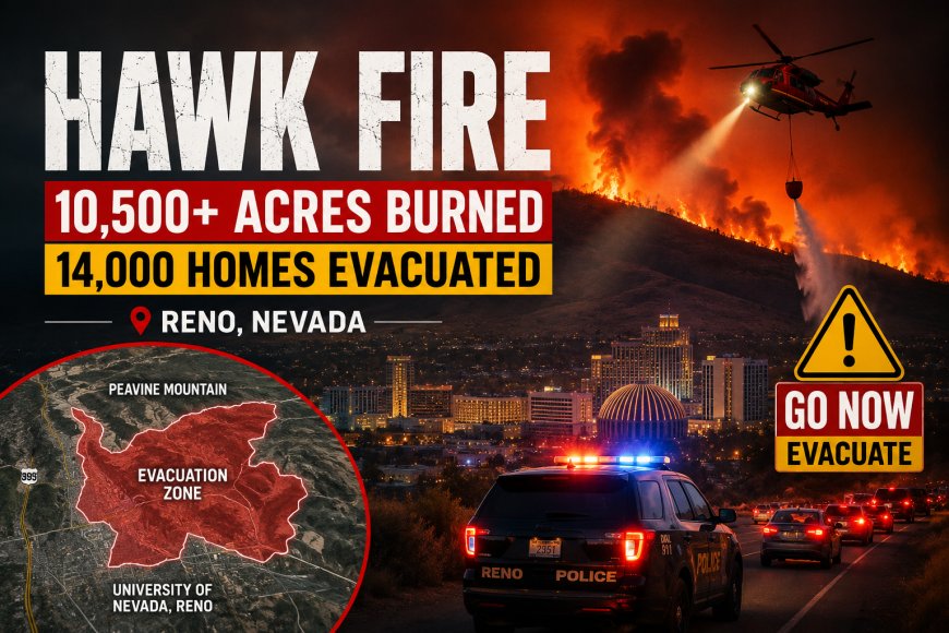
The Hawk Fire near Reno has become a major and rapidly evolving wildfire emergency, with more than 10,500 acres burned, widespread evacuation orders and a state of emergency declared in Washoe County. The fire was reported at 0% containment in Sunday morning coverage, while strong winds continued to make the incident difficult for firefighters to control. Nearly 14,000 homes were under evacuation orders, and the mandatory “GO NOW” area had reached the edge of the University of Nevada, Reno campus.
Why the Hawk Fire is spreading so quickly
The fire has been driven by a combination of strong and erratic winds, very low humidity and dry vegetation. Fire officials have described the incident as highly dynamic because wind-driven flames can move rapidly toward residential areas, leaving crews with difficult decisions about protecting people, homes and critical infrastructure. Reuters reported the fire had reached 10,523 acres, while other Sunday reports placed the size at more than 10,500 acres.
The blaze began in the hills near Peavine Mountain northwest of Reno and expanded dramatically over a short period. That speed is one reason evacuation boundaries have changed quickly and why authorities have repeatedly directed residents to rely on current official maps rather than older screenshots or social-media posts.
How many homes are under evacuation orders?
Nearly 14,000 homes were ordered to evacuate as the fire moved toward populated parts of northwest Reno. Authorities also warned additional residents to be prepared to leave as conditions changed. The scale of the evacuation has made transportation, shelter capacity, road access and power availability major parts of the emergency response.
Residents should pay close attention to the exact evacuation status assigned to their zone. A “GO NOW” instruction is fundamentally different from a preparation warning: people in an evacuation zone should follow official instructions immediately rather than waiting to see flames or smoke approaching their neighborhood.
Where to check the Reno evacuation map
For the latest evacuation boundaries, Washoe County directs residents to official emergency information and Perimeter Map resources. The county's emergency center says its information is approved for media release and provides updates covering evacuations, road closures and other emergency developments.
This matters because wildfire perimeters can change much faster than conventional news articles or social posts. Residents should check the current official map before traveling and should not assume that an earlier evacuation boundary remains accurate.
What roads are closed around Reno?
Road access has also been affected by the fire. An official Washoe County traffic update said northbound U.S. 395 was closed beginning at Parr Boulevard. Residents evacuating from areas north of Red Rock Road were directed to use U.S. 395 to travel north out of the area, while southbound traffic remained open for evacuation traffic. Off-ramps between Red Rock Road and Parr Boulevard were also closed.
Officials have urged people to avoid affected areas unless necessary and to leave emergency routes available for firefighters, police and other response personnel. Anyone planning to evacuate should check current traffic information before starting a journey because closures can change as fire conditions develop.
Is the University of Nevada, Reno under evacuation?
The University of Nevada, Reno said in its latest early-Sunday update that the main campus was not inside an evacuation zone or a “Get Ready” yellow zone at that time. University officials said they were actively monitoring the Hawk Fire and had emergency response and evacuation plans ready if conditions changed.
The distinction is important because the “GO NOW” evacuation area had reached the edge of the university campus, creating understandable concern among students, employees and families. The university also said it was providing assistance to students directly affected by evacuations, including help with temporary housing in appropriate circumstances.
What happened to power service?
Power interruptions became another major consequence of the fire. Local reporting indicated that thousands of customers lost electricity as utility infrastructure was affected and lines were de-energized as a precaution. Reuters also reported that residents were being directed to the Perimeter Map for evacuation information, underscoring how the fire was affecting both neighborhoods and infrastructure.
For residents without power, the safest approach is to follow utility and emergency-management instructions rather than attempting to travel through closed areas to check property. Anyone who depends on electricity for essential equipment should treat an evacuation warning as a serious preparation signal.
Where are evacuees being sent?
Washoe County emergency officials opened the Reno-Sparks Convention Center as an evacuation shelter. Officials have also designated separate locations for animals because pets and livestock could not be accommodated inside the primary human shelter. A local emergency resource page listed the convention center as open while another community center had reached capacity at the time of its update.
The shelter situation demonstrates why residents should prepare evacuation plans before an order becomes urgent. People leaving should consider medications, identification, essential documents, chargers, water, food and supplies for children, older relatives and animals where applicable.
What is the Hawk Fire containment percentage?
The fire was reported at 0% containment in Sunday morning reporting. That figure can change as crews establish control lines, but at the time of the latest reports available for this article, officials were still dealing with an actively spreading fire rather than a blaze that had been brought under control.
More than 400 firefighters and additional aircraft and emergency resources were involved in the response. Nevada also mobilized National Guard resources, including helicopters and personnel, as the state expanded its response to the emergency.
Has the Hawk Fire cause been determined?
No definitive cause should be stated at this stage. CNN reported that the cause remained undetermined. That is important because some early descriptions have characterized the fire differently, but an official determination should be treated as the standard before reporting a specific cause as fact.
The immediate priority remains protecting lives, moving residents out of danger and giving firefighters access to the areas where the fire is advancing. Investigators can determine the origin and cause as conditions allow.
What should Reno residents do now?
Residents in affected areas should follow the evacuation status assigned to their specific zone and monitor official Washoe County emergency information for changes. People under a “GO NOW” order should not wait for additional confirmation from social media or for the fire to become visible from their property. Current evacuation boundaries, road closures and incident information should be checked through official emergency resources and the current perimeter map.
The situation remains active, and conditions can change quickly because of wind. Residents outside evacuation zones should still have essential belongings ready and know which routes they would use if an order expands. The most important information is the current zone status, not an older map or an earlier news update.
What we know about the Reno fire right now
As of the latest verified Sunday reporting, the Hawk Fire had burned more than 10,500 acres, forced evacuation orders affecting nearly 14,000 homes, prompted a state of emergency in Washoe County and remained at 0% containment in the latest major reports. Firefighters were continuing to battle a wind-driven blaze threatening populated areas northwest of Reno.
The emergency is ongoing, so acreage, containment, evacuation boundaries, road closures and shelter conditions may change. For anyone in the Reno area, official emergency information and the latest evacuation map should take priority over older reports.
Frequently asked questions
How big is the Hawk Fire near Reno?
The fire had grown to more than 10,500 acres, with Reuters citing 10,523 acres from Perimeter Map.
How many homes were evacuated?
Nearly 14,000 homes were under evacuation orders in Sunday morning reporting.
Is the University of Nevada, Reno evacuated?
The university said its campus was not in an evacuation or “Get Ready” zone in its latest early-Sunday update, although officials continued monitoring the fire.
Where can residents find the current evacuation map?
Washoe County directs residents to current Perimeter Map information and its emergency information center for evacuation zones and incident updates.
Is the Hawk Fire contained?
The latest major Sunday morning reports available for this article listed the fire at 0% containment.
What's Your Reaction?
 Like
0
 Dislike
0
 Love
0
 Funny
0
 Angry
0
 Sad
0
 Wow
0