























































Gulf Tropical System Could Hit Texas Coast This Week, NHC Warns
The National Hurricane Center is tracking a Gulf tropical system with a 40% chance of development. Texas and Louisiana coasts face a flooding risk this week.
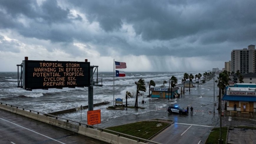
The National Hurricane Center is tracking a developing tropical system in the southwestern Gulf of Mexico that forecasters say could bring tropical storm conditions to the Texas and Louisiana Gulf Coast by the middle of this week, with the potential for heavy rainfall and dangerous flooding even if the system never reaches full tropical storm strength. Designated as a Potential Tropical Cyclone in the Gulf as of Sunday, October 4, the system — forming from a broad area of low pressure in the Bay of Campeche — was given a 40% chance of tropical development over the next seven days as of the NHC's latest outlook, up from the 30% probability issued earlier in the weekend. The NHC says the system is expected to drift northward along the Gulf Coast of Mexico and Texas through the middle of the week, with some slow development possible along the way. Even if the system does not become a named tropical storm, forecasters warn that coastal Texas and Louisiana can expect significant rainfall, gusty winds, and flooding conditions regardless of its official classification.
According to NHC forecasters, precipitation and thunderstorm activity associated with the system continued to increase through Sunday and into Monday, and environmental conditions in the Gulf are described as marginally conducive for development. Computer forecast models — including the European ensemble, which is giving the system higher odds than American models — show the low pressure drifting northward through the Bay of Campeche before turning toward the Texas coast around midweek. The system is expected to reach tropical storm strength by Monday and could undergo more significant intensification Tuesday, though forecasters across all models agree that hurricane-strength winds are unlikely. The primary threats identified by the NHC for the U.S. coastline are scattered to numerous showers and thunderstorms, gusty winds of around 30 knots or greater, and the possibility of tropical funnels in coastal waters.
The most vulnerable areas along the U.S. coastline identified in current NHC marine advisories include Baffin Bay through the Matagorda Ship Channel along the Texas coast, and Terrebonne Bay, Barataria Bay, and Port Fourchon and nearby coastal waters in Louisiana. These are low-lying coastal communities with well-documented flooding histories and limited elevation buffers. Port Fourchon, Louisiana, is a critical hub for the offshore oil and gas industry and serves as a staging point for much of the Gulf's energy infrastructure — making any tropical system in this track a point of concern beyond residential flooding alone. The NHC notes that there is not yet enough information to determine the exact track, intensity, or full land impacts of the system, and residents in coastal Texas and Louisiana should monitor NHC updates closely through the week.
Why the Gulf Tropical System Is Forming After the Quietest Hurricane Season in Decades
The timing of this Gulf development carries a notable irony. The 2026 Atlantic hurricane season produced no hurricane whatsoever during the entire month of September — the first time that has happened in 32 years. Forecasters had expected an active season given elevated Atlantic sea surface temperatures and favorable atmospheric conditions, but a combination of dry Saharan dust outbreaks and unexpected wind shear suppressed storm development through most of the summer. By October 4, the Atlantic had gone more than 330 days since the last hurricane formed in the basin. The quiet season led some meteorologists to suggest publicly that peak threat had passed for many Gulf Coast communities — a conclusion that the current Gulf development is now complicating.
October is historically not outside the range of significant Gulf activity. Several major storms have struck the Gulf Coast during October, including Hurricane Michael in 2018, which made landfall in the Florida Panhandle as a Category 5 storm. While the current 2026 system is not forecast to reach anywhere near that intensity — all major models show a weak tropical depression or modest tropical storm at best — the broader context matters for coastal preparedness. The 2026 season's named storms so far include Arthur, Bertha, Cristobal, Dolly, Edouard, Fay, Gonzalo, and Hanna, with the next available name being Isaias. Fox Weather Hurricane Specialist Bryan Norcross noted that this October Gulf development is a "typical weather pattern for October," driven by a broad Central American Gyre pulling tropical moisture across the Caribbean and into the Gulf.
What Gulf Coast Residents Should Do Right Now
Emergency management officials in coastal Texas and Louisiana routinely advise that preparations for any approaching tropical system should begin well before official warnings are issued — and that residents should not wait for a storm to be named before taking basic precautions. For communities in the projected area of influence, that means ensuring emergency supply kits are stocked with at least 72 hours of water, non-perishable food, medications, and important documents. Residents in flood-prone areas of Galveston, Corpus Christi, Port Arthur, Lake Charles, and coastal Louisiana parishes should review their local evacuation routes and confirm whether they are in a mandatory or voluntary evacuation zone if conditions deteriorate later this week. Storm surge, not wind, remains the leading cause of death in landfalling tropical systems, and even a weak tropical storm making landfall at high tide can push several feet of water across low-lying coastal areas.
As of Monday morning October 5, 2026, the NHC's Tropical Weather Outlook continues to classify the system as having a 40% chance of development over the next seven days, with the agency noting that "some slow development is possible and a tropical depression could form late this week while the system drifts northward." Coastal residents should check the NHC website at nhc.noaa.gov for the most current updates, as track and intensity forecasts for early-stage systems can shift significantly within 24 to 48 hours. Local National Weather Service offices in Corpus Christi, Houston-Galveston, Lake Charles, and New Orleans are the authoritative sources for specific county-by-county impacts as the system's track becomes clearer. The situation remains fluid and will be updated multiple times daily by NHC forecasters through the week.
Gulf Coast Flooding Risk: What to Expect Even Without a Named Storm
One of the most important facts about developing tropical systems that general news coverage frequently underplays is that a storm does not need to be named — or even classified as a tropical depression — to produce serious and life-threatening impacts on land. Potential Tropical Cyclone advisories issued by the NHC are specifically designed to communicate this reality: a system can generate tropical-storm-force winds, dangerous storm surge, and flooding rainfall well before it has an organized circulation. The current Gulf system is expected to produce 4 to 8 inches of rain across parts of South Texas and coastal Louisiana, with isolated maximum totals potentially reaching 10 to 12 inches in the heaviest rainfall bands. For communities that are still recovering from previous flood events — many areas of coastal Texas and Louisiana have faced repeated flooding in recent years — even a disorganized system can cause significant damage to homes, infrastructure, and agricultural land.
The National Hurricane Center's next formal update on the system's development status will provide updated formation probabilities and any watch or warning issuances if conditions warrant. Gulf Coast governors in Texas and Louisiana have the authority to preemptively declare states of emergency to mobilize National Guard resources and pre-position supplies ahead of a storm's arrival. As of October 5, no such emergency declarations have been reported, though local emergency management agencies in the highest-risk areas are actively monitoring the system. Residents should sign up for local emergency alert systems, keep vehicles fueled, and stay away from bayous, streams, and flood-prone areas during any period of heavy rainfall associated with this system, regardless of its official tropical classification when it arrives.
Frequently Asked Questions
Is there a tropical storm warning for the Gulf Coast right now?
As of October 5, 2026, the National Hurricane Center has not issued a formal tropical storm warning, but it is actively tracking a developing system in the southwestern Gulf of Mexico with a 40% chance of becoming a tropical cyclone over the next seven days. Coastal areas from Baffin Bay to the Matagorda Ship Channel in Texas and parts of coastal Louisiana are in the potential impact zone. NHC updates are being issued multiple times daily — check nhc.noaa.gov for the latest.
Which parts of Texas and Louisiana are most at risk?
Current NHC marine advisories identify Baffin Bay through the Matagorda Ship Channel along the Texas coast and Terrebonne Bay, Barataria Bay, and Port Fourchon in Louisiana as the highest-risk coastal areas for gusty winds and rough seas. Low-lying communities near Corpus Christi, Port Aransas, Galveston, and the Louisiana Cajun Coast face the greatest flooding exposure. Residents in these areas should monitor NWS local office alerts for county-specific guidance.
Could this Gulf system become a hurricane?
Current forecast models give very low probability to the system reaching hurricane strength. All major models — including the European ensemble and American GFS — show the system reaching tropical depression or modest tropical storm strength at best. Environmental conditions in the Gulf in October are described by NHC forecasters as "marginally conducive" for development. The greater threat for US coastlines is heavy rainfall and flooding, not wind damage from a major storm.
What's Your Reaction?
 Like
0
 Dislike
0
 Love
0
 Funny
0
 Angry
0
 Sad
0
 Wow
0